GPS ReceiversGPS接收器
A receiver for the Global Positioning System must lock onto the signals from four of the GPS satellites to give a full three-dimensional position. More limited information can be gained from two or three satellites. Different types of receivers make use of different parts of the GPS Signal Structure. The observable quantities are 全球定位系统接收器必须锁定来自四颗GPS卫星的信号,以提供完整的三维位置。从两颗或三颗卫星获得的信息则更为有限。不同类型的接收器会利用GPS信号结构的不同部分。可观测的量是
1. The C/A code on carrier L1 (sufficient for +/-100 m positioning).2. The P-code on carrier L1 3. The P-code on carrier L2 4. The phase of the L1 carrier 5. The phase of the L2 carrier Uses of GPS receivers range from handheld positioning and personal navigation devices to precision surveying tools. Applications of the Global Positioning System require different types of receivers and make use of different parts of the GPS Signal Structure.
1. L1载波上的C/A码(足以实现±100米的定位)。2. L1载波上的P码。3. L2载波上的P码。4. L1载波的相位。5. L2载波的相位。GPS接收机的用途从手持定位和个人导航设备扩展到高精度测绘工具。全球定位系统的应用需要不同类型的接收机,并利用GPS信号结构的不同部分。 |
Index Orbit concepts Reference 索引 轨道概念 参考 | ||||
|
Go Back
返回 |
Handheld GPS Positioners手持式GPS定位器
The most popular type of GPS receiver is a handheld positioning and navigation unit which monitors the C/A code on the L1 carrier of the GPS signal structure. Such units must be used outdoors with a clear view of the sky, and are capable of locking onto the signals from four or more GPS satellites. The signals allow them to calculate the distances to four satellites, and with that data they can calculate position on the earth's surface in latitude and longitude within +/- 100 meters 95% of the time. They can measure altitude to an accuracy of +/- 180 meters. Since the four signals received are stabilized by atomic clocks, the timing accuracy of an ordinary digital watch is sufficient for the calculations done in the handheld unit. Waypoints may be set and stored in the units, and the received signal used to calculate range and direction to those waypoints. Speed and direction of travel can also be displayed. This makes it clear why they have become extremely popular with hikers and hunters.
最流行的GPS接收器是一种手持定位和导航单元,它监测GPS信号结构的L1载波上的C/A码。此类单元必须在户外使用,且需有开阔的视野,能够锁定四个或更多GPS卫星的信号。这些信号使它们能够计算到四个卫星的距离,并利用该数据在纬度和经度上确定地球表面的位置,精度为±100米(95%的时间)。它们可以将高度测量精度达到±180米。由于接收到的四个信号由原子钟稳定,因此普通数字手表的定时精度足以满足手持单元中的计算需求。用户可以在单元中设置和存储路径点,并利用接收到的信号计算到这些路径点的范围和方向。还可以显示行驶速度和方向。这清楚地解释了为什么它们在徒步者和猎人中变得异常流行。 |
Index Orbit concepts Reference 索引 轨道概念 参考 | ||
|
Go Back
返回 |
Differential GPS差分GPS
Position accuracies to about +/- 2 meters can be obtained by comparison of a field GPS receiver with a fixed receiver at a known position. Receivers for this kind of positioning differ from the popular hand-held units in that they have memories for storage of data in both the moving and stationary units and are calibrated to take data at the same time. The field data is then compared to the base station data in postprocessing to obtained the increased accuracy. 位置的精度可达到约±2米,通过将野外GPS接收机与一个已知位置的固定接收机进行比较可以获得。这类定位接收机与流行的便携式单元不同,它们具有存储器,用于在移动和静止单元中存储数据,并且校准以同时采集数据。然后野外数据在后处理过程中与基准站数据进行比较,以获得更高的精度。
This accuracy is obtained using just the C/A code on carrier L1 of the GPS signal structure.
To obtain position uncertainties under a meter in DGPS, receivers must measure both the C/A code and the phase of the L1 carrier. A sequence of phase measurements must be made to achieve the increase in accuracy. For such measurements to be made in real time, a radio link between the base and field stations must be used. A more accurate version of DGPS is called relative positioning GPS. 为在DGPS中获得米级的位置不确定性,接收机必须测量L1载波的C/A码和相位。必须进行一系列相位测量以提高精度。为了在实时中进行此类测量,必须使用基站在场站之间的无线电链路。更精确的DGPS版本称为相对定位GPS。
这种精度是通过仅使用GPS信号结构中L1频段的C/A码获得的。 |
Index Orbit concepts Reference 索引 轨道概念 参考 | ||
|
Go Back
返回 |
Relative Positioning GPS相对定位 GPS
A more sophisticated version of differential GPS is used by surveyors to obtain accuracies on the order of a centimeter for the difference in two positions. The GPS receivers for this process must record the C/A code and the phase of carrier L1 of the GPS signal structure at every epoch of the Navigation Message, on the order of every 12 to 15 seconds. The data from two receivers is postprocessed to obtain the sub-centimeter accuracy. 更先进的差分GPS被测绘人员用来获得两个位置差异的厘米级精度。为了实现这一过程,GPS接收器必须在导航信息的每一个时刻(大约每12到15秒一次)记录C/A码和L1载波的相位。来自两个接收器的数据在后处理中得到亚厘米级的精度。
Maintaining this accuracy for distances over 30 km requires dual frequency receivers that measure the C/A code plus the phases of both carriers, L1 and L2. For both long lines and rapid measurement of shorter distances, receivers make use of all five of the measurable signals of the signal structure. 为了在30公里以上的距离上保持这种精度,需要双频接收机,它们能够测量C/A码以及L1和L2两个载波的相位。对于长距离和短距离的快速测量,接收机都利用信号结构中可测量的五个信号。
|
Index Orbit concepts Reference 索引 轨道概念 参考 | ||
|
Go Back
返回 |
Kinematic GPS运动学GPS
Relative measurements "on the fly" may be made with kinematic packages on GPS receivers, so that accuracies comparable to the relative positioning GPS can be made while moving. Real time kinematic GPS requires a radio link between the field receiver and the base station.
相对定位测量可以在GPS接收机上实时进行,因此在移动中也能实现与常规相对定位GPS相当的精度。实时动态GPS需要场端接收机与基准站之间建立无线电链路。 |
Index Orbit concepts Reference 索引 轨道概念 参考 | ||
|
Go Back
返回 |
GPS Signal StructureGPS信号结构
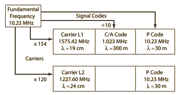
![]() The two carriers and the two signal codes of the GPS system are derived directly from the onboard atomic clock oscillators. By decoding the navigation message from three GPS satellites, the position on the earth can be calculated. GPS系统中的两个载波和两个信号码直接来源于 onboard 原子钟振荡器。通过解码三个 GPS 卫星的导航信息,可以计算出地球上的位置。 |
Index Orbit concepts Reference 索引 轨道概念 参考 | ||
|
Go Back
返回 |