Bilingual edition: English is preserved and Chinese follows each unit. Terminology uses the confirmed v20260916 glossary; automated semantic review remains traceable.
中英双语版:英文原文完整保留,中文紧随对应单元;术语采用 v20260916 确认表,自动语义审校结果可追溯。

Global Positioning Satellites

全球定位卫星

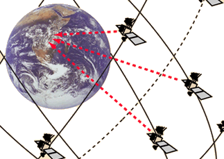
In June of 1993 the last of the 24 satellites of the Global Positioning System was placed into orbit, completing a satellite network capable of providing position data to locate you anywhere on Earth within 30 meters. The satellites carry up to four cesium and rubidium atomic clocks which are periodically updated from a ground station in Colorado. The satellites transmit timing signals and position data. A GPS receiver, which can be a small, hand-held device, decodes the timing signals from several of the satellites, interpreting the arrival times in terms of latitude, longitude, and altitute with an uncertainty which may be as small as 10 meters. In differential mode, accuracies of less than a centimeter can be obtained for distances of hundreds of kilometers. Hand-held units read out longitude and latitude to a thousandth of an arcminute and change in the last decimal place in a couple of paces while walking. The satellites are in orbits much lower than the syncom satellites, orbiting around 17.7 million meters (11000 mi) above the earth, with orbit periods on the order of 10 hours.
1993年6月,全球定位系统(GPS)的第24颗卫星被送入轨道,完成了能够提供位置数据的卫星网络,使用户能够在地球上的任何地点定位,精度可达30米以内。卫星上装有最多四个铯和铷原子钟,这些钟会定期从科罗拉多州的一个地面站更新。卫星发送定时信号和位置数据。GPS接收器可以是一个小型手持设备,它能解码多个卫星的定时信号,将到达时间转换为纬度、经度和高度信息,其不确定性可能小至10米。在差分模式下,对于数百公里的距离,可以达到厘米级的精度。手持设备可以将经纬度读出到千分之一分弧度,并在步行几步内改变最后一位小数。卫星的轨道比同步卫星低得多,轨道高度约为1770万米(11000英里),轨道周期大约为10小时。

From aircraft and ship navigation to finding the favorite fishing hole on the lake, the applications of GPS have multiplied rapidly.

从飞机和船舶导航到在湖中找到最喜欢的钓鱼点,GPS的应用已迅速多样化。
Agricultural applications of GPS
GPS 在农业中的应用
Index

Orbit concepts

Reference
索引 轨道概念 参考
 
HyperPhysics***** Mechanics
力学
R Nave
Go Back
返回


Global Positioning Orbits

全球定位轨道

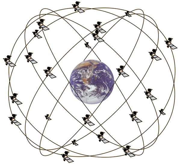
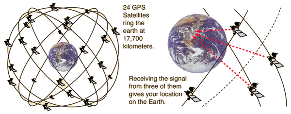
The 24 satellites of the GPS are placed in orbits at about 3.75 times the radius of the Earth. A GPS receiver, which may be a small hand-held unit, can triangulate its position on the Earth's surface within 30 meters or less with signals from three of the satellites. The satellites are arranged in six orbital planes with four satellites in each plane.

GPS的24颗卫星位于地球半径约3.75倍的轨道上。一个GPS接收器(可能是一个小型手持设备)可以利用来自三个卫星的信号,将位置确定在地球表面上的30米以内。这些卫星被安排在六个轨道平面上,每个平面上有四颗卫星。
Index

Orbit concepts

Reference
索引 轨道概念 参考
 
HyperPhysics***** Mechanics
力学
R Nave
Go Back
返回


GPS Navigation Message

GPS 导航信息
The positioning information from GPS satellites is sent in the form of repeating codes which identify the sending satellite, give locations of the other satellites in the system, and give the navigation data. The codes which form the GPS signal structure are superimposed upon two carrier waves in the L-band, a frequency range set aside for satellite communication. Both the carrier frequencies and the signal frequencies are derived directly from the onboard atomic clock oscillator frequency of 10.23 MHz. The coded signals are repeated regularly in epochs on the order of 15 seconds. The codes used are referred to as "pseudo-random codes", a name applied by early radio astronomers who were the first to make wide use of such codes. The codes are well suited to decoding a message embedded in noise signals which may be orders of magnitude larger than the signal itself. Such techniques were valuable in picking up radar echoes off the moon and asteroids. Use of these codes facilitates the sorting out of signals which arrive simultaneously from several GPS satellites.
GPS卫星发送的定位信息以重复码的形式传输,这些码可以识别发送的卫星,提供系统中其他卫星的位置信息,并提供导航数据。构成GPS信号结构的码被叠加在L波段的两个载波波上,L波段是为卫星通信预留的频率范围。载波频率和信号频率均直接来源于 onboard 的原子钟振荡器频率,即10.23 MHz。这些编码信号以约15秒为一个周期重复发送。这些码被称为“伪随机码”,这一名称是由早期无线电天文学家首次广泛使用此类码时所采用的。这些码非常适合解码嵌入在噪声信号中的信息,这些噪声信号可能比信号本身大几个数量级。这种技术在捕捉月球和小行星上的雷达回波时非常有用。使用这些码有助于区分来自多个GPS卫星同时到达的信号。
Index

Orbit concepts

Reference
索引 轨道概念 参考
 
HyperPhysics***** Mechanics
力学
R Nave
Go Back
返回


Global Positioning Triangulation

全球定位三角测量
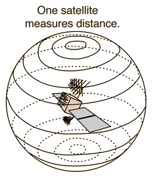
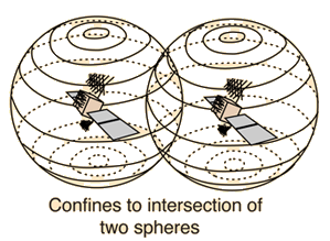
A single satellite can establish range, locating the detector on a sphere.Two satellites can locate the detector on the intersection of two spheres.
一颗卫星可以确定探测器的位置,将其定位在球面上。两颗卫星可以将探测器的位置限定在两个球体的交集上。
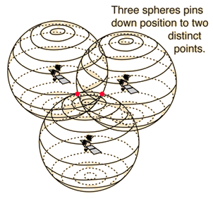
Adding a third as in the GPS system locates it at one of two discrete points where the three spheres intersect. The correct one is easily chosen to get a precise location. The 24 GPS satellites carry atomic clocks to give them the accuracy necessary for position measurement.
添加第三个定位方式,如同GPS系统所做的一样,可以将位置确定在三个球体相交的两个离散点之一。选择正确的位置点可以得到精确的定位。24颗GPS卫星都携带原子钟,以提供定位测量所需的精度。
Index

Orbit concepts

Reference
索引 轨道概念 参考
 
HyperPhysics***** Mechanics
力学
R Nave
Go Back
返回