Convergent Boundaries between Tectonic Plates
板块边界处的汇聚边界
Convergent boundaries where tectonic plates move toward each other generally result in the subduction of one plate into the mantle, consuming part of the lithosphere.
板块相互靠近的汇聚边界通常导致一个板块俯冲到地幔中,消耗了地壳的一部分。
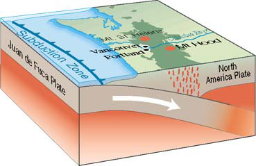
 板块边界突然发生位移可能引发地震和海啸,如2004年12月26日的地震和海啸事件。 |
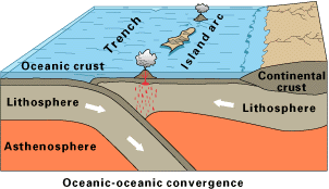
In the case of a convergent boundary between two oceanic plates, one is usually subducted under the other, and in the process a trench is formed. "The Marianas Trench (paralleling the Mariana Islands), for example, marks where the fast-moving Pacific Plate converges against the slower moving Philippine Plate.
在两个海洋板块的汇聚边界处,通常一个板块会俯冲到另一个板块之下,这一过程会形成一个海沟。例如,马里亚纳海沟(对应马里亚纳群岛),就是太平洋板块以较快的速度与移动较慢的菲律宾板块碰撞形成的。 |
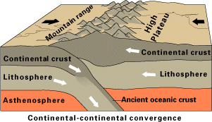 |
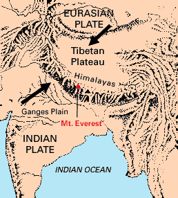
"The collision of India into Asia 50 million years ago caused the Eurasian Plate to crumple up and override the Indian Plate. After the collision, the slow continuous convergence of the two plates over millions of years pushed up the Himalayas and the Tibetan Plateau to their present heights.
5000万年前印度板块与亚洲板块的碰撞使欧亚板块向上褶皱并俯冲到印度板块之上。碰撞之后,两个板块在数百万年中缓慢持续的汇聚作用将喜马拉雅山脉和青藏高原推升到目前的高度。 |
Most of this growth occurred during the past 10 million years. The Himalayas, towering as high as 8,854 m above sea level, form the highest continental mountains in the world. Moreover, the neighboring Tibetan Plateau, at an average elevation of about 4,600 m, is higher than all the peaks in the Alps except for Mont Blanc and Monte Rosa, and is well above the summits of most mountains in the United States."USGS 大部分的生长发生在过去的1000万年中。喜马拉雅山脉,其高度可达海平面以上8,854米,构成了世界上最高的大陆山脉。此外,邻近的青藏高原,平均海拔约为4,600米,除了勃朗峰和罗莎峰外,比阿尔卑斯山脉的其他所有峰顶都高,而且高于美国大多数山脉的峰顶。USGS
|
 美国地质调查局 |
| Plate Tectonics
板块构造 |
这是美国地质调查局(USGS)的插图。其位置是 http://pubs.usgs.gov/gip/dynamic/dynamic.html 。挑战者深渊位于马里亚纳海沟的南端,深入地球内部(近11,000米),比世界最高峰珠穆朗玛峰高出海平面(约8,854米)的海拔要深。
Geophysics concepts
索引 地球物理学概念
| HyperPhysics | R Nave |
返回