Paleomagnetism
古地磁学
Studies of the magnetic field orientations in rock strata reinforced the case for plate tectonics.
对岩层中磁场方向的研究加强了板块构造理论的论据。
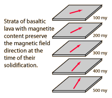 | Iron-rich magnetic minerals such as magnetite are present in basaltic lava flows. A characteristic of ferromagnetism is that it disappears when you heat the material above a temperature known as the Curie temperature, which is 1043K for pure iron, but is reported to be about 850 K (580°C) for magnetite. When these minerals drop below their Curie temperatures in the process of solidifying, they are slightly magnetized in the direction of the Earth's magnetic field at this time. This forms a durable record of the direction of the magnetic field of the Earth at the time of solidification.
富含铁的磁性矿物,如磁铁矿,在玄武岩熔岩流中存在。铁磁性的特征是当材料被加热到一个称为居里温度的温度以上时,这种特性会消失。对于纯铁,居里温度是1043K,但对于磁铁矿,据报道约为850 K(580°C)。当这些矿物在凝固过程中温度低于其居里温度时,它们会略微被磁化,方向与当时地球磁场的方向一致。这形成了地球磁场在凝固时刻方向的持久记录。
|
The magnetic North and South poles of the Earth correspond closely, although not exactly, with the spin axis of the Earth. Although the mechanism of generation of the magnetic field, called the geodynamo, is not fully understood, it is clear that it has something to do with the rotation of the Earth and the presence of mobile materials with significant electrical conductivity which can circulate. Mars has a similar rotation rate, but apparently no mobile conductors and therefore no appreciable magnetic field. Because of the enormous angular momentum of the Earth and the absence of a source of torque to change that angular momentum, we can presume that the spin axis has remained essentially constant in space.
地球的磁北极和磁南极与地球自转轴大致对应,尽管并不完全一致。虽然地磁发电机(geodynamo)的机制尚未完全理解,但显然与地球的自转和具有显著电导率的可移动物质的循环有关。火星有相似的自转速率,但显然没有可移动的导体,因此没有显著的磁场。由于地球具有巨大的角动量,并且缺乏改变该角动量的力矩源,我们可以推测地球自转轴在空间中基本上保持不变。 | 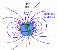
|
The magnetic field at any point on the Earth would orient a compass in the direction of magnetic North. The compass needle is a mobile magnet that rotates to align with the magntic field. Measurement of the magnetic field direction at a point on the Earth could tell you where the magnetic North pole is at that time, but you would have to measure the dip angle as well as the direction parallel to the surface to imply the pole location.
地球上的任何一点的磁场会使罗盘指向磁北方向。罗盘指针是一个可以移动的磁体,会旋转以与磁场对齐。测量地球上某一点的磁场方向可以告诉你该时刻磁北极的位置,但你还需要测量俯角以及与表面平行的方向来确定极点位置。
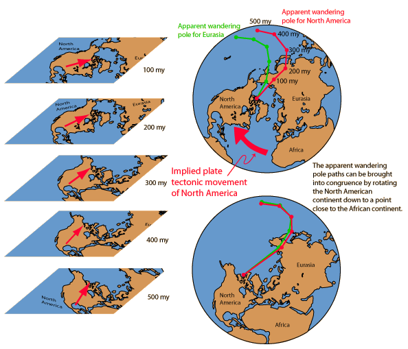
The illustration below follows the treatment of Lutgens and Tarbuck who trace the evidence for plate tectonics that comes from the study of the magnetization of minerals. Studies of lava flows in Europe during the 1950s and later in North America showed a change in the orientation of the magnetic field with the age of the lava. This was taken as evidence that the magnetic poles "wandered" over the surface of the Earth. But given the stability of the Earth's rotation axis and it's association with the magnetic field generation as discussed above, it seems more likely that the land mass itself had "wandered", i.e., undergone plate tectonic movement.
下图遵循Lutgens和Tarbuck的处理方式,他们追踪了来自矿物磁化研究的板块构造证据。20世纪50年代欧洲和随后北美对熔岩流的研究显示,磁化方向随熔岩年龄发生变化。这被解释为地球磁极在地表“游移”。但鉴于地球自转轴的稳定性及其与磁场所述的关联,似乎更可能的是陆地本身发生了“游移”,即发生了板块构造运动。
A problem arose with the comparison of the Eurasian and North American studies, since they showed different paths for the "pole wandering". But it was found that if you migrated the North American continent over toward the African continent, the curves came into congruence. The "problem" of different pole wandering paths became powerful evidence that the continents themselves had changed their relative positions in comparison to a presumably almost stationary magnetic pole.
在比较欧亚和北美研究时出现了问题,因为它们显示了‘极移’的不同路径。但发现如果将北美大陆向非洲大陆迁移,曲线就变得一致。‘问题’即不同极移路径,成为大陆之间相对位置发生变化的有力证据,而这一变化是相对于一个 presumably 几乎 stationary 的磁极而言的。
|
Index
Reference
Lutgens and Tarbuck
Ch 16
索引 参考 Lutgens 和 Tarbuck 第16章 |