Europa's Surface as Seen by Galileo
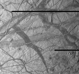 NASA 从伽利略轨道器获取的图像 | This view of Jupiter's moon Europa shows a portion of the surface that has
been highly disrupted by fractures and ridges. This picture covers an area
about 238 kilometers (150 miles) wide by 225 kilometers (140 miles), or
about the distance between Los Angeles and San Diego. Symmetric ridges in
the dark bands suggest that the surface crust was separated and filled with
darker material, somewhat analogous to spreading centers in the ocean basins
of Earth. Although some impact craters are visible, their general absence
indicates a youthful surface. The youngest ridges, such as the two features
that cross the center of the picture, have central fractures, aligned knobs,
and irregular dark patches. These and other features could indicate
cryovolcanism, or processes related to eruption of ice and gases.
This picture was taken at a distance of 40,973 kilometers (25,290 mi) on
November 6, 1996 by the Galileo spacecraft solid state imaging television
camera onboard the Galileo spacecraft during its third orbit around Jupiter.
这张木星卫星欧罗巴的图像显示了表面的一部分,该部分受到裂缝和隆起的严重破坏。这张照片覆盖的区域大约宽238公里(150英里),高225公里(140英里),大约相当于洛杉矶到圣地亚哥的距离。暗带中的对称隆起表明,表面的 crust 被分离并填充了较暗的物质,这在某种程度上类似于地球海洋盆地的扩张中心。尽管可以看到一些撞击坑,但它们的普遍缺失表明这是一个年轻的表面。最年轻的隆起,如照片中心交叉的两个特征,具有中央裂缝、对齐的突起和不规则的暗色斑块。这些和其它特征可能表明冰火山活动,或与冰和气体喷发相关的过程。这张照片是在1996年11月6日由伽利略号航天器上的固态成像电视摄像机拍摄的,拍摄距离为40,973公里(25,290英里),当时是伽利略号绕木星进行的第三次轨道飞行。 |
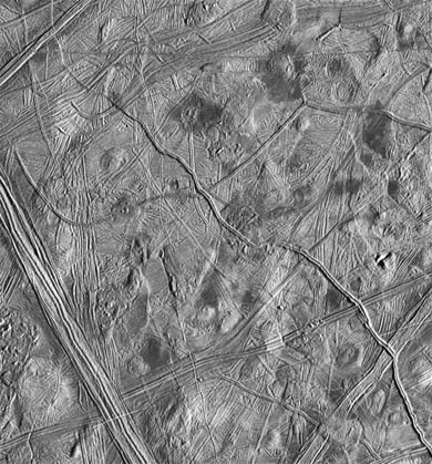 | This moderate-resolution view shows the complex icy crust that has been extensively modified by fracturing and the formation of ridges. The ridge systems superficially resemble highway networks with overpasses, interchanges and junctions. From the relative position of the overlaps, it is possible to determine the age sequence for the ridge sets. For example, while the 8-kilometer-wide (5-mile) ridge set in the lower left corner is younger than most of the terrain seen in this picture, a narrow band cuts across the set toward the bottom of the picture, indicating that the band formed later. 这张中等分辨率的图像显示了被断裂和形成山脉所广泛改造的复杂冰壳。这些山脉系统在外观上类似于高速公路网络,有高架桥、立交桥和交汇点。根据重叠物的相对位置,可以确定山脉组的年龄顺序。例如,虽然图像左下角宽8公里(5英里)的山脉组比图像中看到的大部分地形更年轻,但一条狭窄的带状物横跨该组,位于图像底部,表明该带是在之后形成的。 |
In turn, this band is cut by the narrow 2- kilometer-wide (1.2-mile) double ridge running from the lower right to upper left corner of the picture. Also visible are numerous clusters of hills and low domes as large as 9 kilometers (5.5 miles) across, many with associated dark patches of non-ice material. The ridges, hills and domes are considered to be ice-rich material derived from the subsurface. These are some of the youngest features seen on the surface of Europa and could represent geologically young eruptions.
This area covers about 140 kilometers by 130 kilometers (87 miles by 81 miles) and is centered at 12.3 degrees north latitude, 268 degrees west longitude. Illumination is from the east (right side of picture). The resolution is about 180 meters (200 yards) per pixel, meaning that the smallest feature visible is about a city block in size. The picture was taken by the Solid State Imaging system on board the Galileo spacecraft on February 20, 1997, from a distance of 17,700 kilometers (11,000 miles) during its sixth orbit around Jupiter.
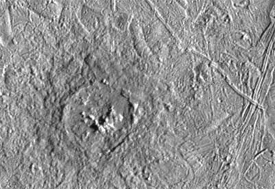 | This is a more detailed view of Pwyll crater , which is shown in the southern hemisphere of a full view of Europa. It was photographed by the Solid State Imaging system on the Galileo spacecraft on February 20, 1997 during its sixth orbit around Jupiter. It was at a distance of 12,000 km (7,500 mi) from Europa. 这是普利陨石坑的更详细视图,该陨石坑在欧罗巴全视图的南半球中显示。这张照片是1997年2月20日,伽利略探测器绕木星第六次轨道飞行时,由伽利略飞船上的固态成像系统拍摄的。当时它距离欧罗巴约12,000公里(7,500英里)。 |
This impact crater is located at 26 degrees south latitude, 271 degrees west longitude, and is about 26 kilometers (16 miles) in diameter. Lower resolution pictures of Pwyll Crater taken earlier in the mission show that material ejected by the impact can be traced for hundreds of miles across the icy surface of Europa. The dark zone seen here in and around the crater is material excavated from several kilometers (a few miles) below the surface. Also visible in this picture are complex ridges.
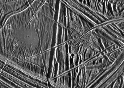 | This close-up view of the icy surface of Europa, a moon of Jupiter, was obtained on December 20, 1996, by the Solid State Imaging system on board the Galileo spacecraft during its fourth orbit around Jupiter. The view is about 13 kilometers by 18 kilometers (8 miles by 11 miles) and has a resolution of 26 meters (28 yards). The Sun illuminates the scene from the east (right). 这张是木星卫星欧罗巴冰层表面的特写图像,于1996年12月20日由伽利略探测器上的固态成像系统在绕木星第四轨道期间拍摄。图像尺寸约为13公里乘18公里(8英里乘11英里),分辨率为26米(28英尺)。太阳从东边(右方)照射此场景。 |
| Europa Discussion
欧罗巴讨论 |
Jupiter Concepts
Solar System Illustration
Solar System Concepts
References
Chaisson & McMillan,
Ch 11.
| HyperPhysics********** Astrophysics
HyperPhysics ********** 天体物理学 | R Nave |