Earth's Moon
 NASA Image NASA 图像 |
This is a color composite image of the Moon taken by the Galileo Orbiter on December 9, 1990 at a range of about 350,000 miles. The color composite image made use of monochrome images taken through violet, red, and near-infrared filters. The concentric, circular Orientale basin, 600 miles across, is near the center; the near side is to the right, the far side to the left. At the upper right is the large, dark Oceanus Procellarum; below it is the smaller Mare Humorum. These, like the small dark Mare Orientale in the center of the basin, formed over 3 billion years ago as basaltic lava flows. At the lower left, among the southern cratered highlands of the far side, is the South-Pole-Aitken basin, similar to Orientale but twice as great in diameter and much older and more degraded by cratering and weathering. The cratered highlands of the near and far sides and the Maria are covered with scattered bright, young ray craters. (from the original NASA caption released with the image.) 这张图片是1990年12月9日由伽利略探测器拍摄的月球彩色合成图像,拍摄距离约为350,000英里。该彩色合成图像利用了通过紫光、红光和近红外滤光片拍摄的单色图像。中心是一个直径600英里的同心圆形奥里恩塔盆地,右侧是近侧,左侧是远侧。右上角是广阔的暗色普罗克拉图洋,其下是较小的赫尔姆霍茨海。这些,就像盆地中心的较小暗色奥里恩塔海一样,是在约30亿年前由玄武岩熔岩流形成。在左下角,位于远侧南部撞击坑密集的高地之中的是南极-艾廷盆地,与奥里恩塔盆地相似,但直径大一倍,而且更古老,受到更多的撞击和风化作用影响。近侧和远侧的撞击坑密集的高地以及玛丽亚都被散落的明亮、年轻的射线撞击坑覆盖。(该图片原始的NASA说明文字)
|

NASA Image
This full moon view was taken from the Apollo 11 spacecraft on its journey homeward on July 21, 1969. It was taken from a distance of about 10,000 nautical miles from the Moon.
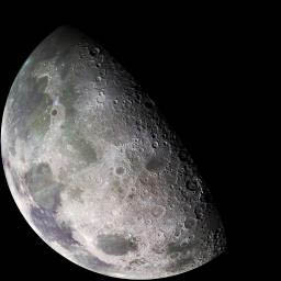 | 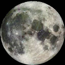 |
The image at left above is a North polar mosaic image of the Moon made by the Galileo Orbiter on Dec 7, 1992. The left part of this north pole view is visible from Earth. The image was assembled from 18 images taken by Galileo's imaging system through a green filter. The left part of this picture shows the dark, lava-filled Mare Imbrium (upper left); Mare Serenitatis (middle left), Mare Tranquillitatis (lower left), and Mare Crisium, the dark circular feature toward the bottom of the mosaic. Also visible in this view are the dark lava plains of the Marginis and Smythii Basins at the lower right. The Humboldtianum Basin, a 650-kilometer (400-mile) impact structure partly filled with dark volcanic deposits, is seen at the center of the image. The Moon's north pole is located just inside the shadow zone, about a third of the way from the top left of the illuminated region.
The full moon view above right was taken by Galileo on the same day. The distinct bright ray crater at the bottom of the image is the Tycho impact basin. The dark areas are lava rock filled impact basins: Oceanus Procellarum (on the left), Mare Imbrium (center left), Mare Serenitatis and Mare Tranquillitatis (center), and Mare Crisium (near the right edge). This picture contains images through the Violet, 756 nm (red) , 968 nm (infrared) filters. The color is 'enhanced' in the sense that the CCD camera is sensitive to near infrared wavelengths of light beyond human vision. These descriptions are excerpted from the original NASA captions.
 NASA Image NASA 图像 |
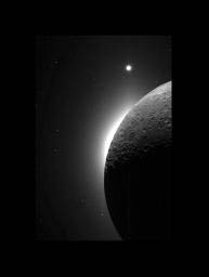
Clementine Observes the Moon, Solar Corona, and Venus 克莱门蒂观察月球、日冕和金星 In 1994, during its flight, the Clementine spacecraft returned images of the Moon. In addition to the geologic mapping cameras, the Clementine spacecraft also carried two Star Tracker cameras for navigation. These lightweight (0.3 kg) cameras kept the spacecraft on track by constantly observing the positions of stars, reminiscent of the age- old seafaring tradition of sextant/star navigation. These navigation cameras were also to take some spectacular wide angle images of the Moon. In this picture the Moon is seen illuminated solely by light reflected from the Earth-- Earthshine! The bright glow on the lunar horizon is caused by light from the solar corona; the sun is just behind the lunar limb. Caught in this image is the planet Venus at the top of the frame. 1994年, Clementine 探测器在飞行过程中返回了月球的图像。除了地质测绘相机外,Clementine 探测器还携带了两台星图相机用于导航。这些轻便的(0.3 kg)相机通过持续观测恒星的位置来保持探测器的航向,这让人联想到古老航海传统中的六分仪/星导航。这些导航相机还将拍摄一些壮观的广角月球图像。在这张图片中,月球仅被地球反射的光所照亮——地球光!月球地平线上明亮的光辉是由太阳日冕的光造成的;太阳正位于月球边缘的后面。这张图片中还捕捉到了位于画面顶部的行星金星。
|
 NASA Image NASA 图像 |
This view of the north polar region of the Moon was obtained by Galileo's camera during the spacecraft's flyby of the Earth- Moon system on December 7 and 8, 1992. The north pole is to the lower right of the image. The view in the upper left is toward the horizon across the volcanic lava plains of Mare Imbrium. The prominent crater with the central peak is Pythagoras, an impact crater some 130 kilometers (80 miles) in diameter. The image was taken at a distance of 121,000 kilometers (75,000 miles) from the Moon through the violet filter of Galileo's imaging system. According to team scientists, the viewing geometry provided by the spacecraft's pass over the north pole and the low sun-angle illumination provide a unique opportunity to assess the geologic relationships among the smooth plains, cratered terrain and impact ejecta deposits in this region of the Moon (excerpted from the original NASA caption). 这张月球北极区域的图像是在1992年12月7日和8日航天器飞越地球-月球系统时,由伽利略号相机拍摄的。图像中,北极为图像的右下方。左上角的视图是朝向横跨伊玛尔海的火山熔岩平原。显著的撞击坑中央有山峰,这是皮塔哥拉斯撞击坑,直径约130公里(80英里)。该图像是在距月球121,000公里(75,000英里)处,通过伽利略号成像系统中的紫色滤光片拍摄的。据团队科学家所述,航天器飞越北极提供的视图几何和低太阳角度照明提供了评估该地区月球平滑平原、有撞击坑的地形和撞击喷射物沉积物之间地质关系的独特机会(摘自原始NASA说明)。
|
Moon Concepts
Solar System Illustration
Solar System Concepts
| HyperPhysics********** Astrophysics
HyperPhysics ********** 天体物理学 | R Nave |