The Pale Blue Dot淡蓝色点
The late 20th century brought the capability to actually observe the planet Earth from space. One of the iconic photos was provided by Voyager I in its last series of photos before it left the solar system, the photo known as the Pale Blue Dot. ![]() The photo was taken by Voyager's camera on February 14, 1990, just 34 minutes before it powered off its cameras (Photo credit NASA/JPL-Caltech). It was a part of a final 60 image photo collection termed the "Family Portrait of the Solar System". The popular name of this view is traced to the title of the 1994 book by Voyager imaging scientist Carl Sagan, who originated the idea of using Voyager's cameras to image the distant Earth. 这张照片是1990年2月14日由旅行者号的相机拍摄的,就在其关闭相机34分钟之前(照片版权:NASA/JPL-Caltech)。这是最终60张照片的一部分,被称为“太阳系全家福”。这种视角的通俗名称源自1994年旅行者影像科学家卡尔·萨根所著的书籍标题,他提出了利用旅行者号相机拍摄遥远地球的构想。
20世纪后期,人类首次具备了从空间观察地球的能力。其中一张标志性照片是由旅行者一号在离开太阳系前最后拍摄的一系列照片中提供的,这张照片被称为“淡蓝色点”。 The image of the Earth was taken from a distance of 3.8 billion miles (6 billion kilometers). This is the most distant view of the Earth. Turning the cameras back toward the Earth at an earlier stage posed risks to the camera systems because of the closeness of the Earth to the Sun and the brilliance of the Sun. The band of light in which the Earth image appears is sunlight scattered in the camera.
地球的图像是在距离地球38亿英里(60亿公里)处拍摄的。这是地球最远的视图。在更早的阶段,将摄像机转向地球会带来风险,因为地球靠近太阳,且太阳的光辉非常强烈。地球图像出现的光带是阳光在摄像机中散射形成的。 |
Index Solar System Illustration Solar System Concepts NASA Pale Blue Dot Revisited 索引 太阳系示意图 太阳系概念 NASA 浅蓝色点 revisited | ||
|
Go Back
返回 |
Earth as Seen Through Saturn's Rings通过土星环观测的地球
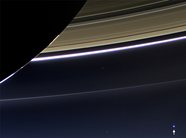
![]() "From 898 million miles away, Earth appears as a tiny blue dot in this wide angle photograph from the Cassini spacecraft." (Image credit: NASA/JPL-Caltech/Space Science Institute) 从89800万公里外的地球看来,这张宽角度照片中,地球呈现出一个微小的蓝色光点。(图片版权:NASA/JPL-Caltech/Space Science Institute) |
Index Solar System Illustration Solar System Concepts Explorer1 galleries 索引 太阳系图示 太阳系概念 探索者1 图集 | ||
|
Go Back
返回 |
Earth and Moon as Seen from Mercury水星上看到的地球和月亮
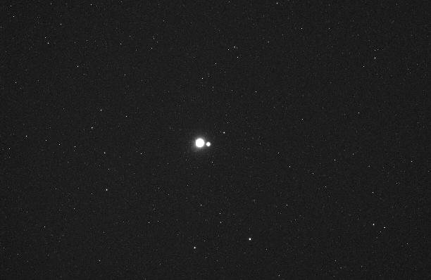
![]() In 2010 "on its way to orbit Mercury, the Messenger robotic spacecraft looked back and took this photograph showing Earth and the Moon as small circles of reflected light from a distance equal to the view from Mercury. Launched in 2004, Messenger's mission to the Sun's closest planetary neighbor ended with a dramatic, planned impact in 2015." (Image credit: NASA/Johns Hopkins University Applied Physics Laboratory/Carnegie Institution for Science)
2010年,当“信使号”(Messenger)探测器正前往水星轨道时,该机器人探测器回望并拍摄了这张照片,显示地球和月球作为从水星视角远处反射光的小圆圈。该探测器于2004年发射,其任务结束于2015年的一次戏剧性的计划撞击。 (图片版权:NASA/约翰霍普金斯大学应用物理实验室/卡内基科学研究所) |
Index Solar System Illustration Solar System Concepts Explorer1 galleries 索引 太阳系图示 太阳系概念 探索者1 图集 | |||
|
Go Back
返回 |
Earthrise地球升起
![]() This classic image of the Earth from space was taken by Astronaut William Anders on the Apollo 8 mission. Apollo 8, launched on December 21, 1968, was the first manned vehicle to navigate around the Moon, and this photo changed our view of our home planet in a dramatic way. 这张由宇航员威廉·安德斯在阿波罗8号任务中从空间拍摄的地球经典图像,展示了我们星球的全貌。阿波罗8号于1968年12月21日发射,是第一艘绕月航行的载人航天器,这张照片以戏剧性的方式改变了我们对地球的认知。
|
Index Solar System Illustration Solar System Concepts 索引 太阳系示意图 太阳系概念 | ||
|
Go Back
返回 |
Earthrise 2.0地球升起 2.0
![]() The Earthrise 2.0 image was taken in 2015 by the Lunar Reconnaissance Orbiter (LRO). The LRO was launched in 2009 and captures about 10 Earthrises daily, "but is generally busy looking at the Moon's surface." (Image credit NASA/Goddard/Arizona State University). 2015年,月球勘测轨道器(LRO)拍摄了Earthrise 2.0图像。LRO于2009年发射,每天拍摄约10次Earthrise,但通常主要关注月球表面。(图片资料:NASA/戈达德/亚利桑那州立大学)
|
Index Solar System Illustration Solar System Concepts 索引 太阳系示意图 太阳系概念 | ||
|
Go Back
返回 |
The Blue Marble蓝宝石
![]() This image of the Earth is a classic one over the continent of Africa. This is the famous "Blue Marble" image taken on December 7, 1972 by the Apollo 17 astronauts. It was taken from a distance of about 18,000 miles as they were traveling to the Moon. (credit NASA Johnson Space center). 这张地球的图片是关于非洲大陆的经典图像。这是1972年12月7日由阿波罗17号宇航员拍摄的著名“蓝宝石”图像。当时他们正前往月球,拍摄距离约为18,000英里。(资料来源:NASA约翰逊空间中心)
|
Index Solar System Illustration Solar System Concepts 索引 太阳系示意图 太阳系概念 | ||
|
Go Back
返回 |
The Earth/Moon System地球/月球系统
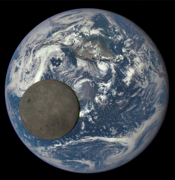
![]() "The rarely seen "dark side" is visible as the Moon moves in front of the sunlit side of Earth. This unique 2015 view was captured by a NASA's Earth Polychromatic Imaging Camera (EPIC) aboard the Deep Space Climate Observatory (DSCOVR) satellite. DSCOVR's primary mission is real-time solar wind monitoring for the National Oceanic and Atmospheric Administration (NOAA), while EPIC maintains a constant view of the fully illuminated Earth as it rotates, providing scientific observation of ozone, vegetation, clout height and aerosols in the atmosphere. DSCOVR is a partnership between NASA, NOAA, and the U.S. Air Force. (Image credit: NASA/NOAA) 很少见的‘暗面’在月球位于地球被阳光照亮的一面之前显现出来。这张独特的2015年照片是由搭载在深空气候观测卫星(DSCOVR)上的美国国家海洋和大气管理局(NOAA)的地球多色成像仪(EPIC)拍摄的。DSCOVR的主要任务是为NOAA实时监测太阳风,而EPIC则持续观察地球的完全光照面,随着地球自转,提供对大气中的臭氧、植被、云层高度和气溶胶的科学观测。DSCOVR是由NASA、NOAA和美国空军共同合作的项目。(图片资料:NASA/NOAA)
|
Index Solar System Illustration Solar System Concepts Explorer1 galleries 索引 太阳系图示 太阳系概念 探索者1 图集 | ||
|
Go Back
返回 |